


Understanding low-visibility navigation in modern warfare
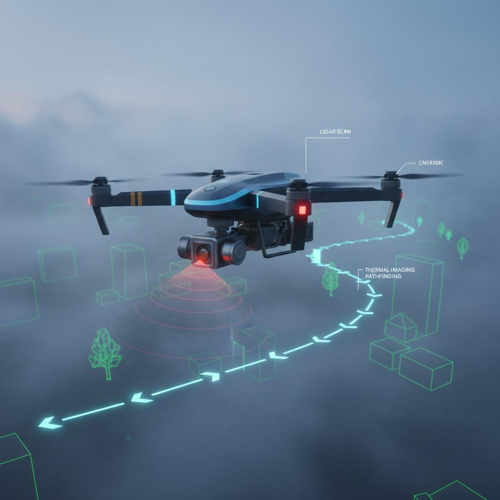
Low-visibility navigation has become a cornerstone for industries requiring reliable operation in harsh environments. Even in fog, night, or severe weather conditions that limit visibility, this technology enables seamless movement and data acquisition. For example, drones equipped with advanced sensors such as LiDAR and thermal imaging can maintain precise paths, ensuring safety and efficiency. In all-weather operations, low-visibility navigation excels by combining GPS with inertial measurement units, enabling continuous operation in a wide range of conditions. This is particularly important for applications where downtime could result in significant losses or risks.
Advanced navigation technology enables all-weather operation
All-weather operations directly benefit from low-visibility navigation systems, which enable unmanned vehicles and aircraft to operate in adverse weather conditions such as rain, snow, or dense fog. These systems use real-time data processing to dynamically adjust flight paths, thereby avoiding collisions and optimizing energy use. For example, in agriculture, farmers rely on these technologies to conduct field surveys in unpredictable weather conditions, ensuring uninterrupted monitoring of crop health. Low-visibility navigation enhances all-weather operational capabilities by providing redundancy in navigation methods, such as combining visual odometry with radio frequency signals. This robustness not only extends the operational window but also reduces maintenance costs over time, making it an indispensable tool for sustained productivity.
Precision agricultural monitoring using low-visibility technology
Precision agriculture monitoring revolutionizes farming by collecting detailed environmental data using low-visibility navigation technology. Drones or ground robots navigate crop rows in low-light conditions, using multispectral cameras to assess soil moisture, pests, and nutrient levels. This precise approach minimizes resource waste, such as over-fertilization, thereby increasing yields and enabling sustainable farming. Low-visibility navigation technology ensures all-weather operation, allowing for uninterrupted monitoring even at dawn or dusk. Farmers gain actionable information to guide irrigation and planting decisions, ultimately improving farm efficiency and profitability in variable weather conditions.
Conducting infrastructure inspections under harsh conditions
Infrastructure inspections demand extremely high precision, especially in hazardous areas such as bridges, power lines, and pipelines. Low-visibility navigation technology enables inspection drones to map and scan structures in foggy or nighttime conditions, identifying cracks or wear before they develop into failures. This technology supports all-weather operation, enabling year-round assessments and reducing potential safety hazards caused by human intervention. For urban planners and engineers, integrating low-visibility navigation technology into their daily work means proactive maintenance, extending the lifespan of critical assets and minimizing disruption to public services.
Search and rescue missions relying on low-visibility navigation
In search and rescue missions, low-visibility navigation can guide rescue teams through smoke-filled forests, turbulent seas, or collapsed buildings, saving lives. Rescue drones equipped with AI-driven path planning systems can quickly cover large areas and deploy sensors to detect heat sources or moving targets. This capability enables all-weather operation, even in severe weather conditions with zero visibility, such as blizzards or torrential rain. Precision agricultural monitoring technologies are being applied to help map disaster areas, allowing for more targeted searches. Recent success stories from natural disasters demonstrate how low-visibility navigation can shorten response times, increase survival rates, and accelerate community rebuilding.
The Future of Low Visibility Navigation Across Industries
Looking ahead, low-visibility navigation will continue to evolve with the development of machine learning, further enhancing its capabilities for all-weather operations, precision agriculture monitoring, infrastructure inspection, and search and rescue missions. As sensor costs decrease and integration increases, wider applications will drive innovation in autonomous systems. Industries will benefit from safer and more efficient workflows, highlighting the technology's crucial role in building resilient operations to address environmental uncertainties.