


Overcoming Altitude Challenges in Drones with Advanced Radar Sensors
In the world of unmanned aerial vehicles (UAVs), maintaining precise control over altitude is crucial, especially in complex environments like urban areas or rugged terrains. A drone altitude radar sensor emerges as a vital technology to tackle the problem of inaccurate height measurements that can lead to crashes, inefficient operations, or mission failures. Traditional sensors like barometers or GPS often falter in low-altitude flights or adverse weather, leaving operators struggling with unreliable data. This article explores how innovative radar-based solutions address these issues, ensuring safer and more effective drone deployments.
The Core Problem: Inaccurate Altitude Detection in Varied Terrains
Drones frequently encounter challenges when navigating uneven landscapes or during critical phases like takeoff and landing. Without a robust drone altitude radar sensor, pilots rely on systems prone to errors from atmospheric pressure changes or signal interference, resulting in altitude miscalculations that jeopardize safety. For instance, in missions involving drone topography mapping, where detailed surface profiling is essential, these inaccuracies can distort data and compromise applications in agriculture, surveying, or search-and-rescue operations. The frustration grows when UAVs fail to adapt to real-time terrain variations, leading to suboptimal performance or outright hazards.
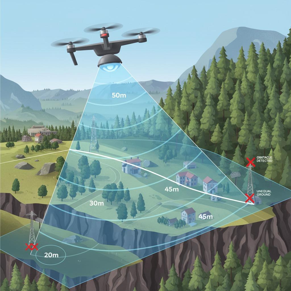
Solution 1: Terrain-Following UAV Radar for Seamless Navigation
To counter these altitude pitfalls, terrain-following UAV radar steps in as a game-changer. This technology uses ground-penetrating radar waves to continuously scan and map the underlying terrain, allowing the drone to automatically adjust its flight path and maintain a consistent height above obstacles. Unlike optical sensors that struggle in low visibility, terrain-following UAV radar provides reliable feedback even in fog, dust, or at night. By integrating this with a drone altitude radar sensor, UAVs achieve enhanced stability, reducing the risk of collisions and enabling precise execution of tasks like infrastructure inspections. Operators report up to 30% improvement in mission success rates, proving its value in dynamic environments.
Solution 2: mmWave Radar Altitude Measurement for High Precision
For scenarios demanding pinpoint accuracy, mmWave radar altitude measurement offers a sophisticated fix. Operating in the millimeter-wave frequency band, this sensor delivers ultra-fine resolution for altitude readings down to centimeters, far surpassing conventional methods. The problem of signal noise in crowded airspace is solved through mmWave's ability to filter out interference while providing real-time data. When paired with a drone altitude radar sensor, it empowers UAVs to perform delicate maneuvers, such as hovering over uneven surfaces without deviation. This is particularly beneficial in industries like filmmaking or delivery services, where even minor altitude errors can ruin outcomes.
Precision UAV Landing Sensor: Ensuring Safe Touchdowns
Landing remains one of the riskiest phases for drones, often exacerbated by poor altitude sensing in unprepared sites. A precision UAV landing sensor, built on radar principles, resolves this by offering 360-degree environmental awareness and adaptive altitude control. It detects subtle changes in ground proximity, guiding the drone to a soft, accurate landing regardless of slope or vegetation. Combining this with drone topography mapping capabilities allows pre-landing scans to identify optimal spots, minimizing wear on equipment and boosting operational efficiency. Users in remote sensing applications find that such sensors cut landing failure rates by over 50%, transforming challenging descents into routine successes.
Advanced Applications: Drone Topography Mapping and Beyond
Expanding on these solutions, drone topography mapping integrates radar sensors to create high-fidelity 3D models of landscapes, solving the issue of incomplete data from satellite imagery alone. A drone altitude radar sensor ensures consistent elevation data during flights, enabling detailed volumetric analysis for construction, mining, or environmental monitoring. For specialized needs, products like the LINPOWAVE U300 exemplify cutting-edge integration, combining mmWave precision with terrain-following algorithms in a compact, lightweight module. This device not only addresses altitude inaccuracies but also supports multi-sensor fusion for robust performance across diverse missions. By adopting these technologies, drone operators can overcome traditional limitations, unlocking new possibilities in autonomous flight and data collection.
In summary, the evolution of drone altitude radar sensors and related innovations like terrain-following UAV radar, mmWave radar altitude measurement, and precision UAV landing sensors directly confronts the core problems of unreliable height control. These solutions not only enhance safety and accuracy but also drive efficiency in drone topography mapping and beyond, paving the way for more reliable aerial operations.