


Introduction: Tackling the Complexity of Urban Traffic
Urban streets are busy, unpredictable, and increasingly crowded. Pedestrians, cyclists, and vehicles all compete for limited space, and traditional sensing systems—like cameras or inductive loops—often fail under fog, rain, or low light. This can lead to blind spots, delayed responses, and accidents that could have been prevented.
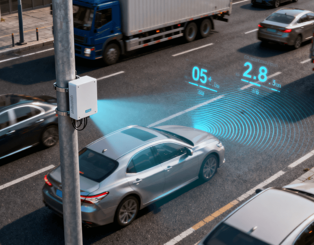
This is where millimeter-wave (mmWave) radar comes in. By providing precise, real-time measurements of distance, speed, and angle, mmWave radar allows smart traffic systems to see, think, and act—almost like giving the city a nervous system.
1. How mmWave Radar Perceives the Urban Environment
1.1 Seeing Through the Fog (Literally)
Unlike cameras, mmWave radar doesn’t care about lighting or weather. Fog, rain, or dust won’t stop it from detecting objects reliably. This robustness makes it ideal for intersections, crosswalks, and highway monitoring.
A TI study on automotive mmWave radar shows detection accuracy remains high even in low-visibility conditions.
1.2 Multi-Target Tracking in 3D
Thanks to FMCW radar, multiple moving targets—cars, motorcycles, and pedestrians—can be tracked in three dimensions. This is crucial for predictive traffic management: a sudden jaywalker or a fast-approaching vehicle can be detected and acted upon in milliseconds.
1.3 Real-Time Data Flow
Urban traffic doesn’t wait, and neither can sensors. mmWave radar delivers near-instantaneous data, allowing systems to respond quickly to sudden changes—a key advantage over cameras, which may lag in low-light conditions.
2. Practical Applications in Traffic Systems
2.1 Smart Intersections
Imagine an intersection that adapts in real time. mmWave radar detects vehicles and pedestrians, feeding data to traffic lights that adjust dynamically. This reduces waiting times, lowers the risk of collisions, and keeps traffic moving smoothly.
2.2 Collision Avoidance Networks
Roadside radar can communicate with vehicles via V2X (Vehicle-to-Everything). For instance, if a car is speeding toward a crosswalk, both the driver and nearby pedestrians can be alerted instantly, preventing potential accidents before they happen.
2.3 Lane-Level Traffic Flow Analysis
High-resolution radar can measure the speed, spacing, and trajectory of every vehicle in multiple lanes. Cities can then optimize signal timing, reroute traffic, and quickly respond to emergencies.
Learn more about Linpowave’s Automotive & Traffic Radar Solutions deployed in smart city projects worldwide.
3. Integrating mmWave Radar into Intelligent Traffic Systems
3.1 Sensor Fusion
Radar works best when paired with cameras or LiDAR. Cameras help identify object types and shapes, while radar provides reliable distance and speed data. Combining them creates a richer, more reliable picture of the traffic environment.
3.2 AI-Powered Decisions
Raw data is useful, but AI turns data into action. Algorithms analyze radar inputs to detect anomalies, predict movements, and optimize traffic lights in real time. For example, an intersection can prioritize a bus that is running late while still ensuring pedestrian safety.
3.3 V2X Connectivity
Radar data integrated into V2X networks allows vehicles to “see” beyond their line of sight. This reduces collisions, improves traffic flow, and lays the groundwork for autonomous vehicle adoption.
4. Real-World Examples
4.1 Urban Intersection Pilot
A pilot project in a busy city installed Linpowave radar at a complex intersection. Within months:
-
Pedestrian detection accuracy reached 95% in low-light and foggy conditions
-
Minor accidents dropped by 30%
-
Dynamic traffic light adjustments cut average waiting times by 20%
4.2 Highway Monitoring
Highway radar modules tracked lane-level speed and spacing. Real-time alerts for speeding vehicles improved safety while keeping traffic flowing smoothly—without intrusive physical barriers.
5. Overcoming Challenges
5.1 Multi-Path Interference
Urban environments create reflections from buildings. Linpowave radar uses advanced filtering and clustering algorithms to distinguish real targets from false echoes.
5.2 Cost vs. Coverage
Deploying radar across an entire city is expensive. Linpowave’s compact, modular radar units offer a cost-effective solution, allowing phased deployment without compromising safety.
5.3 Managing High-Volume Data
High-resolution radar generates significant data. AI-based analytics platforms help cities process this information efficiently, turning raw measurements into actionable traffic insights.
6. FAQ: mmWave Radar in Smart Traffic
Q1: How does mmWave radar improve traffic safety compared to cameras?
A1: It functions reliably in low light, fog, rain, or dust, detecting vehicles, pedestrians, and cyclists consistently.
Q2: Can radar detect multiple targets at once?
A2: Yes. FMCW radar enables simultaneous 3D tracking of multiple moving objects.
Q3: Is radar compatible with autonomous vehicles?
A3: Absolutely. Radar data integrates into V2X networks to provide real-time awareness for connected and autonomous vehicles.
Q4: Where is mmWave radar typically deployed?
A4:
-
Urban intersections for adaptive signals
-
Highways for speed and lane monitoring
-
Pedestrian and cyclist safety zones
-
Smart city traffic optimization
Q5: Can AI enhance radar for predictive traffic control?
A5: Yes. AI analyzes radar data to forecast vehicle movements, detect anomalies, and optimize traffic flow.
Conclusion: From Perception to Proactive Traffic Management
mmWave radar is transforming urban traffic by giving systems precise, real-time perception. When combined with AI, sensor fusion, and V2X, cities can anticipate problems before they occur, reduce accidents, and pave the way for autonomous urban mobility.
Explore more: