


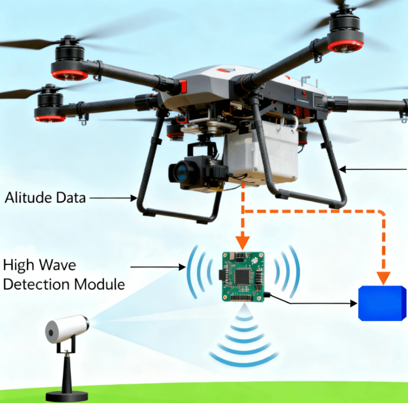
Controlling altitude during low-altitude UAV flights, precise landings, or operations over complex terrain has always been a challenge. Many drone pilots have experienced this: ultrasonic sensors giving fluctuating altitude readings near buildings, barometers affected by wind and temperature changes, and LiDAR failing in foggy conditions. For drones to hover steadily at low altitudes, traditional sensors are often insufficient.
The U200A millimeter-wave radar addresses these challenges. It works reliably in all weather conditions, delivers high-precision real-time altitude data, and provides clear value for drone manufacturers, system integrators, and even DIY UAV enthusiasts.
Challenges in Low-Altitude Drone Operations
Drones face three main challenges when flying close to the ground:
-
Unstable Hovering
Traditional ultrasonic sensors are prone to multipath reflections near buildings or the ground, causing inconsistent hover altitude. Even small errors can affect aerial photography, spraying, or inspection tasks. -
Difficulty Following Terrain
Flying over hills, uneven ground, or dense foliage, a single sensor often cannot accurately detect terrain changes, leading to deviations from safe flight paths. -
Environmental Interference
Optical and LiDAR sensors struggle in fog, rain, or dusty conditions, producing unreliable measurements. According to the IEEE UAV Sensor Study, millimeter-wave radar maintains stable measurements under challenging environmental conditions, making it ideal for low-altitude UAV operations.
How Millimeter-Wave Radar Enhances UAV Accuracy
The U200A operates in the 77–81 GHz band using FMCW (Frequency Modulated Continuous Wave) technology. Here’s why it solves the challenges mentioned above:
-
High Precision
Maintains ±0.2 m accuracy even during low-altitude hovering or over complex terrain. -
Wide Measurement Range
Covers 0.2 m to 200 m, suitable for low to mid-altitude flights. -
All-Weather Reliability
Performs consistently in fog, rain, dust, and low-light conditions. -
Fast Response
With a 20 Hz update rate, the drone receives near-real-time altitude data for precise control.
Check out the Linpowave UAV Solutions page for real-world integration cases. Simply put, the U200A gives drones a “height-sensing eye,” improving safety and reliability.
U200A Key Specifications and Real-World Experience
| Parameter | Specification | Notes |
|---|---|---|
| Frequency Band | 77–81 GHz | High interference resistance, all-weather operation |
| Measurement Range | 0.2–200 m | Suitable for low- and mid-altitude flights |
| Accuracy | ±0.2 m | Under typical conditions |
| Refresh Rate | 20 Hz | Real-time altitude feedback |
| Interfaces | TTL/CAN/RS422 | Compatible with common flight controllers |
| Operating Environment | -40~85°C, 5–90% RH | Reliable under harsh conditions |
| Dimensions / Weight | 70×50×5.5 mm / ~10 g | Lightweight and easy to install |
Installation and Integration Tips
From practical experience, a few details make a significant difference:
-
Mounting Angle: Keep the radar facing the ground and avoid tilting beyond its vertical field of view.
-
Interface Matching: Select TTL, CAN, or RS422 according to your flight controller; test on the ground before flight.
-
Low-Altitude Testing: While the module can measure down to 0.2 m, real-world testing below 5 m ensures stable hovering.
-
Sensor Fusion: Integrating with IMU, GPS, or optical sensors can further improve accuracy and safety.
Real-World Applications
-
Precision Landing
Drones can automatically detect landing platform altitude, ensuring smooth landings even on rooftops or ship decks. -
Agricultural Spraying
Real-time altitude feedback ensures even spraying over uneven farmland. -
Power Line Inspection
Terrain-following functionality keeps the drone stable along power lines or wind turbine blades, reducing collision risks.
Studies like NASA’s UAV Terrain-Following Research demonstrate the effectiveness of millimeter-wave radar in complex terrain operations.
Industry Value and ROI
Using U200A millimeter-wave radar offers clear benefits:
-
Reduced Accident Risk: Accurate altitude measurements minimize landing or collision errors.
-
Increased Operational Efficiency: Automated low-altitude hovering and terrain following reduce manual intervention.
-
Cost-Effective: Compared to multi-sensor setups, the U200A is lightweight, highly integrated, easy to install, and requires minimal maintenance.
Frequently Asked Questions (FAQ)
Q1: How accurate is the U200A below 5 m altitude?
A: Accuracy remains around ±0.2 m under typical conditions, but real-world testing is recommended.
Q2: How does it interface with flight controllers?
A: Supports TTL, CAN, and RS422; SDK and documentation are provided for integration.
Q3: Can it operate in fog or rain?
A: Yes, millimeter-wave radar is highly resistant to environmental interference.
Q4: What is the power consumption?
A: Approximately 2 W, supporting 5V/1A, 12V/0.5A, or 13–30V power input.
Q5: Is customization available?
A: Yes, measurement range, output interface, or firmware features can be customized to meet UAV requirements.
Conclusion and Next Steps
The U200A millimeter-wave radar provides UAVs with real-time, high-precision, all-weather altitude sensing. Lightweight, easy to install, and highly reliable, it’s an ideal partner for low-altitude hovering, terrain-following, and precision landing.
To make your UAV flights safer and more precise, download the U200A datasheet or contact us for custom solutions. Let your drone truly “see” its altitude.